Hazelwood – Hazelwood North – historical snippets
By Leo Billington
It’s time to highlight parts of Hazelwood’s history. Previous items published in the CDN have covered the Hazelwood North Creamery, Hazelwood Railway Station and Hazelwood North’s infamous morass.
There are, however, more lesser known items of interest.
One is reminded of a neighbourhood in Brunswick West where street signs are complemented with discreet finger signs indicating where small suburban businesses were once located at the turn of the century. We’re informed a butcher was down here, a grocer in this street, a church (now demolished) was on this corner and so on.
It’s a real pity we seemingly have ignored past historical snippets, yet signage would adequately reflect and acknowledge a past not that long ago.
Jessie Shaw
There are old maps showing road easements reminiscent of earlier times. One of these is Jessie Shaw Lane, Hazelwood North.
Janet, who became known as Jessie, was Donald Shaw’s sister. Other siblings were Sally, Neil, Coll, and John. With their parents, Archibald and Ann, their Hazelwood North property was named Otterburn. Donald was the first Morwell Shire President from 1892 to 1893. Jessie came to this district with her parents when a young woman, in about 1867, having travelled by dray from Werribee. She selected a block of land at Hazelwood North, but lived with her brother Donald, for whom she kept house until his marriage. At 92 years of age, Jessie died in September 1937.

Jessie’s obituary recalled that “when she arrived in the district, Rosedale was the nearest township. The late Mr John MacMillan had a cattle run extending from Driffield to North Hazelwood. Among his boundary riders were the late Findlay McKay and Bob Burrows, better known as Black Bob, an intelligent aboriginal, who was a fine rider and a popular chap, among the early settlers.”
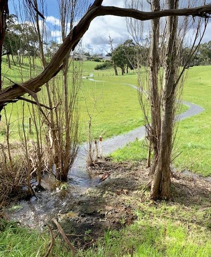
Today, Jessie Shaw Lane is rather overgrown with long grass and riparian vegetation growing along the edge of a drain which feeds into Waterhole Creek, where an elderly fence roughly defines one side of her laneway.
Black Bob’s Lane
Jessie Shaw’s obituary brings our attention to Black Bob’s Lane. In that 1937 obituary, it’s revealed “there is a property close to The Ridge, that is still known as Black Bob's paddock, formerly owned by the late John Macmillan.”
Aboriginal man, Bob Burrows (also known as ‘Black Bob’), worked as a boundary-rider for squatter John MacMillan at Hazelwood station in the 1860s. He was a popular figure in the district and was respected as a fine horseman (Traralgon Record 1 May 1914 – page 4). Local personality at the time, Llew Vary, provided valuable historical insights through his series, ‘Harking Back - recollections of early Morwell’. In Part Three, Morwell Advertiser (Thursday August 13, 1942), Llew wrote about Bob Burrows:

“Another local identity who comes to my memory is Robert Burrows (Black Bob) a half cast, who later selected 320 acres, part of which is now occupied by Alf Bruce. He was a goodhearted fellow who could not read or write. My mother once told me that he was sent by Mr Macmillan across the river, which was in flood, to enquire how my father was. He had been sick for about three weeks. When mother saw him riding up the track she met him saying, "Bob I want you to catch another horse and ride to Sale and bring the Doctor," and without any questions Bob set off about 5 p.m. on a July evening, arriving back with the doctor, before 11 a.m. next, day. I mention this to show what the women of those days (who are so seldom mentioned and who played such a big part) had to go through.”
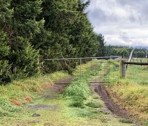
Today, public access is denied to what’s left of Black Bob’s Lane. A locked gate seemingly stands guard over an interesting chapter of Hazelwood’s history. Most of the lane is under the Hazelwood pondage anyway.
Plough Creek

Local maps will show various creeks meandering towards Morwell. Their origins are in the Jeeralang high country. Eel Hole Creek is well known as is Wilderness Creek. Bennetts and Waterhole Creek seem to be mates, each running almost parallel in their haste towards town. Plough Creek runs a sinuous route from the Jeeralangs, skirting Morwell’s eastern boundary onward to West Traralgon.
Again, in acknowledgement of Llew Vary in his ‘Harking Back - recollections of early Morwell’; Part Three, Morwell Advertiser (Thursday, August 6, 1942), Llew wrote an explanation of how Plough Creek came by its name:
“The mention of Plough Creek reminds me how this so-called creek came by its name. In the very early days, a plough was borrowed from Merton Rush by a Traralgon Station and on returning, the party got bogged and left the plough by the side of the road to be picked up at a later date. It laid there all the winter and people travelling through began to call the place Plough Creek. I would like to mention here that this plough was made solely of wood except for the share and was the only plough in the district at that time. It also had a history, as it was brought from Sydney by John King, already mentioned and given by him to his man Charlie Farley, who had taken up Merton Rush. I can remember as a boy seeing this plough behind the old stable, left to decay and what a relic it would be now if only it had been preserved.”
Another theory about the creek’s name was that Patrick McGauran, who had settled near the creek in 1869, immediately east of Morwell’s boundary, was an innovative farmer. Apparently, and how this story goes, Patrick or his son John was the first local farmer to obtain a plough. He hosted a celebratory function on-site showcasing the newly acquired asset. Many locals, all curious to see what had been purchased, agreed to name the creek in honour of Morwell’s first plough.
Historical recollections such as this tend to converge. The plough hypothesis is interesting in the least. It’s great in the telling. It does seem that the discarded plough was in the boggy creek adjacent to the McGauran’s farm. One could conclude it was an acquired asset, resplendent in its derelict condition.


